We therefore made “bad luck, good heart” (the best of a bad job), the ash was not the main thing that spoiled the season, the weather conditions did. Indeed, the direction of the “bad” wind, the one that made the plume pass above our heads, was about 310°, orientation far too North to give good waves because the subtropical air masses are too warm and humid and, in general, anticyclonic, and it is well known that it is not so much the speed of the wind that defines the intensity of a wave system, but more its temperature, its temperature gradient and its density (so, the colder, more stable and drier airmass, the more powerful the wave).
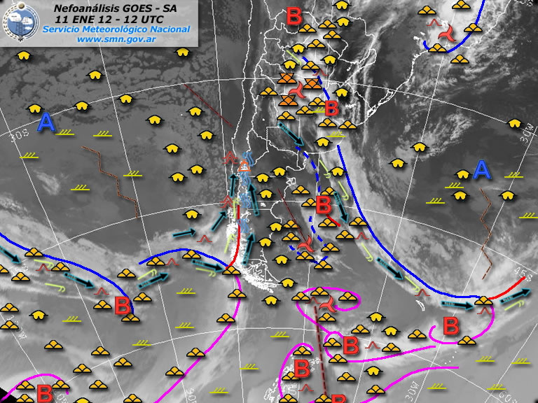
Then, when the wind direction turned below 280°, we recovered with great pleasure the legendary purity of the Patagonian air and its fabulous waves, to a degree where, taken by the rage to fly at any cost and considering the particular conditions we were facing, we learned to fly with South wind, therefore parallel to the main line of the Andes, the technique being, in fact, the same we apply in the Alps, flying up and down from rebound to rebound, from peak to peak (positive wave), from lake to lake (negative wave) with the only difference that we had no landable field within a radius of 100 km, so “bye bye, high speeds”! But flying deep inside the Andes offers an unforgettable spectacle that replaces with great pleasure any speed or distance records. The figure below shows the situation on January 11th, where the wind at altitude blew 30 to 40 kt full south, while it was, as usual, 20kt/300° on the ground. A rare situation but no less interesting.
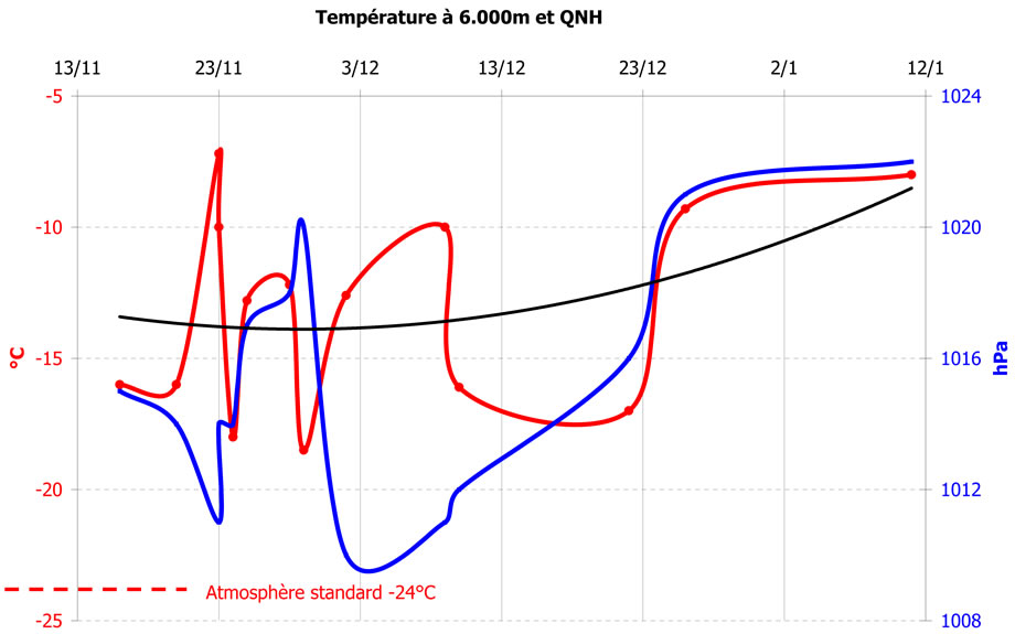
These anomalies of pressure and temperature have been reported in the diagram below, where we have plotted the temperature at 6000m together with the QNH at the take-off time. The first observation is that the temperature has always been above the standard (-24°C). The average is even 10°C above the standard and it is my opinion that this is the most meaningful phenomenon, since, ten years ago, it was around the standard. A warm up of 10°C in altitude is a real atmospheric cataclysm, whose consequences are completely unknown and unpredictable, this phenomenon being apparently ignored by the meteorologists and climatologists who keep their eyes on their thermometers on the ground or on the remaining polar ice! One more reason, in my humble opinion, for reducing the impact of human activities on global warming and an interesting subject for a debate about “environmentalism” and anthropo-centrism!” A glance on the curve of the QNH corroborates the moving down of the anticyclone 1000km southbound, or isn’t it rather the opposite? One could also say, that the temperature increase might only be the consequence of the pressure centres shifting. Messrs meteorologists, you have the chair, I remain at your disposal to start the debate.
Consequently, the gliding activity has been the lowest of these last ten years with only 160 hours and 30 flying days out of 65 available days. The situation deteriorated continuously from mid-November, with periods of up to nine consecutive non-flyable days in December, essentially for lack of wind due to the positions and the strength of the anticyclones. The few thermal days were hard to fly because of the ash, which was put back in circulation by the convection. And since the two nearest emergency strips to the north and south (respectively 80 km and 100 km) were unusable for take off, no one wanted to take the risk of derigging the Nimbus in the ash!
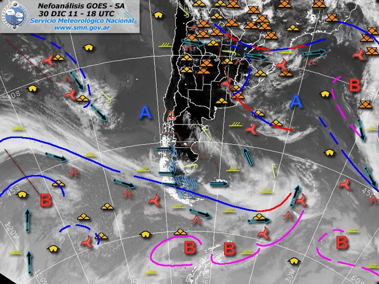
The figure below shows the situation of December 30 after seven days without a breath of wind, on the other hand very nice for swimming in a mirror lake. The Pacific high pressure centre is just 1.000 km too South and the one on the Atlantic took the place of the usual low-pressure centre, which is the engine of the system, the one that “pulls” the flow and keeps the jet-streams blowing. The situation in the southern Patagonia was locally very good between 500 km and 1.000 km South from Bariloche, hopeless for us, but so good for Jean-Marc.