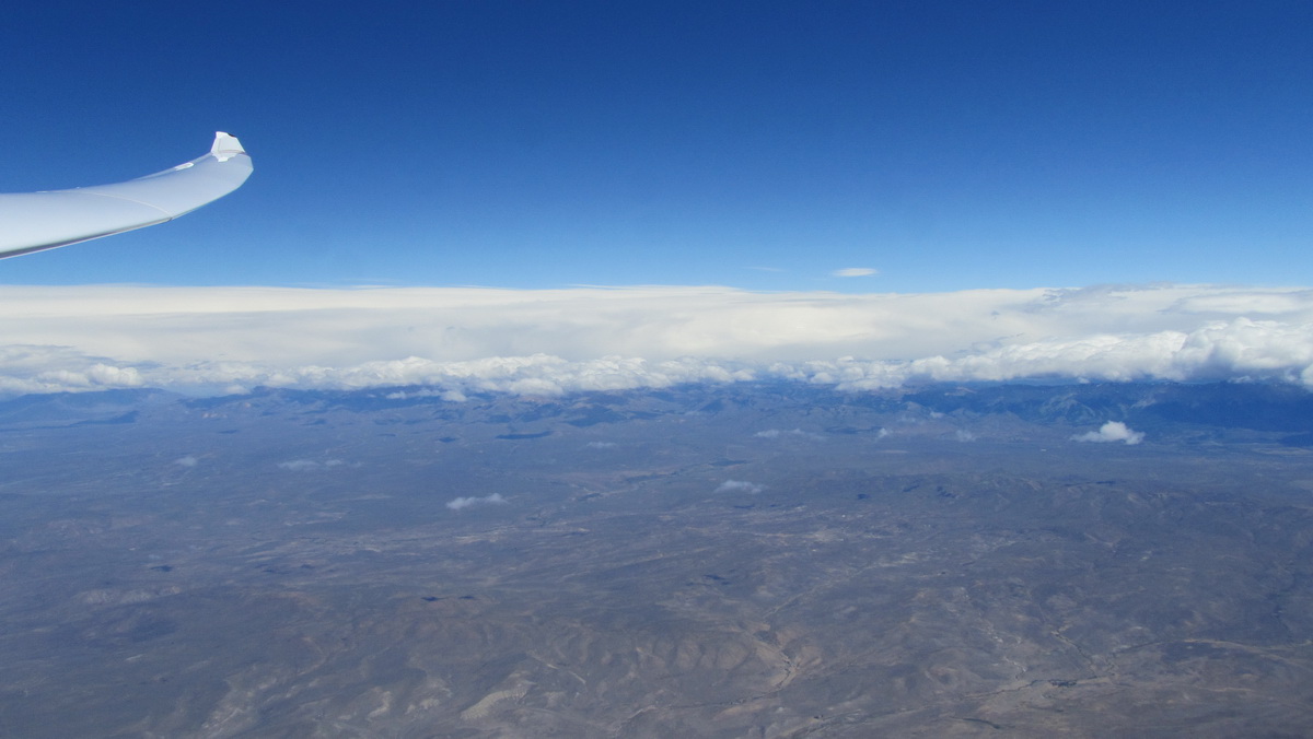
I am sure the reader will have read and understood the twenty-seven pages of chapter 7 of my book Dancing With the Wind, and since beautiful images worth more than a long speech, the captions of the photos will delight him. I do not know if the increase in the frequency of appearance of hydraulic jumps is a consequence of the climate change or the result of a better understanding of the phenomenon following the studies leading to the writing of my book, or more probably the combination of both. Still, a lot of West-South-West wind days allowed me to identify their presence and exploit them to the delight of my pilots. However, and this is an important novelty, I saw for the first time the supercritical flow descending down to the pampa ground level, downwind of the Cordón de Esquel, which became unrecognizable and unusable, devoid of any undulatory movement, laminated, wiped off by the supercritical flow up to the front of the jump located 40 km downwind of the crest, see photo. I would never have continued the task in the blue if I had not understood this phenomenon by reading the sky, whose length was about 200 km, except that our turnpoint was inside the incoming cold front. I had a professional IFR pilot with me, an IR aircraft, a trained crew and no risk of icing, no worry, we go. Great, Fabrice! IGC file here.
Between a front entering from the south and the absence of north wind at the beginning of the day, we declare a 3 turnpoint of 1,500km, with a comfortable take off at 9am local time. Catching the wave on the ridge is too long, few minutes of engine directly to our starting point gives 8 m/s, never seen this year; yesterday it was 0.5 m/s. After reaching the clearance FL 230, all works very well despite a wind of 120-140 km/h, but the 1/8 SCu of the early morning quickly becomes 4/8, disorganized, the south turn point at km 300 is in the clouds, the front is just there. So we decide to fly these few km in the front because the ground can minimally be seen just below us, we are not very high (5.000m), the gyros are running just in case, but we shall not need them. Let’s turn the point in the sector on the Oudie’s display 7km from the turnpoint, which is in the cloud, unflyable. We are lucky! Back on tiptoe in a system completely unstructured by the arrival of the front. The lift is too weak to stop to climb, we just slowly move northbound maintaining 4,000m MSL during 200km traveled in 1h1/2, that’s long! It is necessary to shift downwind of the range 40km to find exploitable rebounds in straight line, but not to climb (probable hydraulic jump in formation, the flow seems supercritical), then all returns to work normally arriving near home. Given the time required to fly the first 500 km (average 130 km/h), we have no illusion about the outcome of the “as declared” task. The rest is classical except that the plain from Chapelco to the north is totally blue. We go on tiptoe taking advantage of the wake wave of volcano Lanin (it works as in my book!) and I start for a long 110 km glide in the blue to reach the Catan Lil range, which gives us a good 4 m/s at 4,500m. Miracle, the first lenticulars are just forming as we move towards Loncopué, a marvel, especially as Buenos Aires gives us clearance to FL 250, that we will have trouble maintaining with 5 m/s at the Vne ! Temperature is only -20 ° C at 8.000m, very comfortable. The last Metar of Bariloche is not good, 6/8 of SC at 3000ft, visibility 5 km for intense rain, it is necessary to turn back home in order to keep a reserve of 2 hours of light for a possible outlanding diversion. Buenos Aires is happy to transfer us to Bariloche TWR because the weather situation is seriously worsening, the airport is now IMC. A friendly controller advises me to wait about twenty minutes, because according to him, the situation may improve. We slow down and we go up, we’ll see later. This is not in the official procedure, but it works! At 6,000m and 70 km, we glimpse a shape that looks like the lake and the last 40 km are flewn with visibility exclusively vertical in heavy rain. Good news for Fabrice, who flies back to Paris tomorrow!
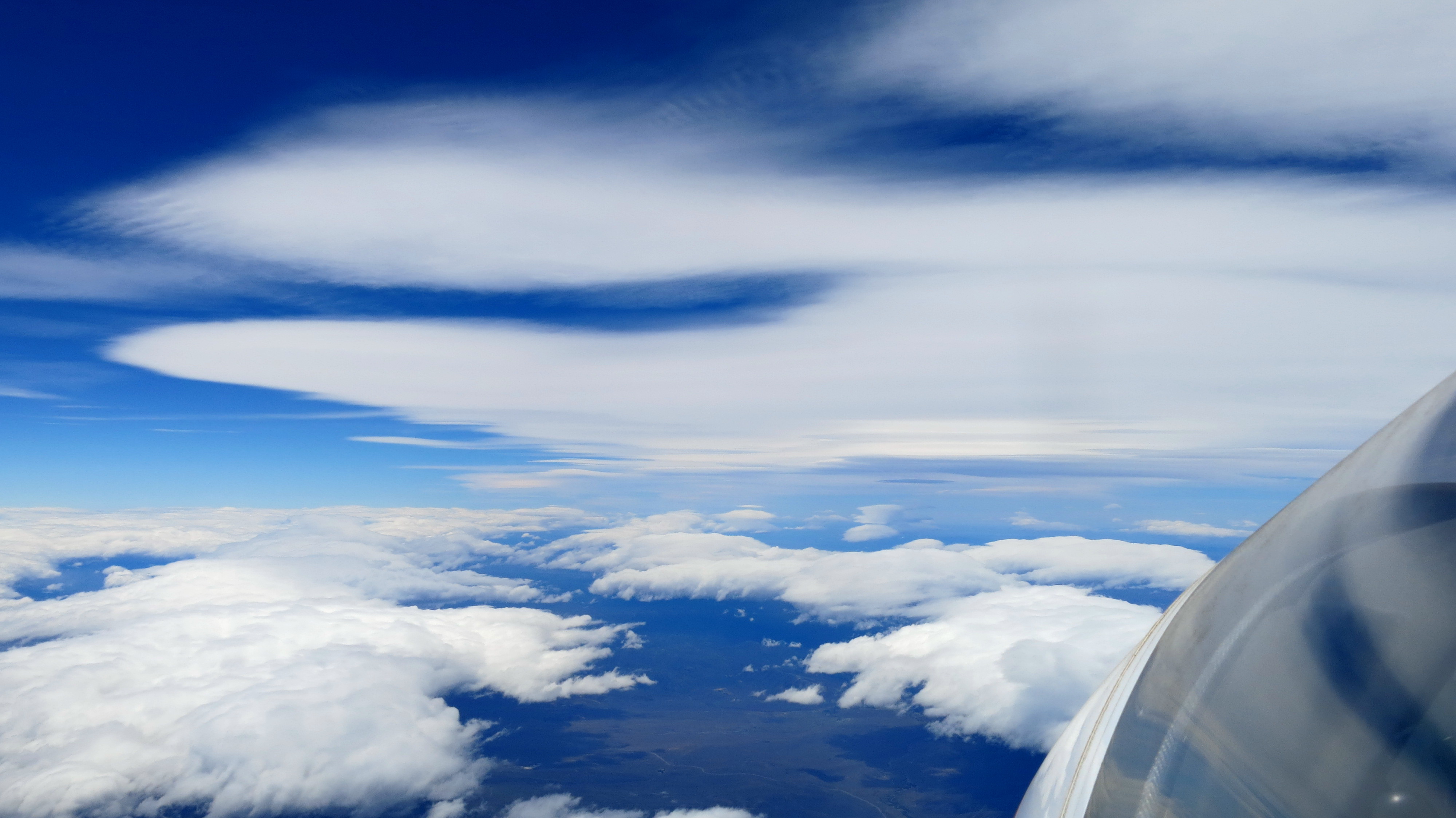
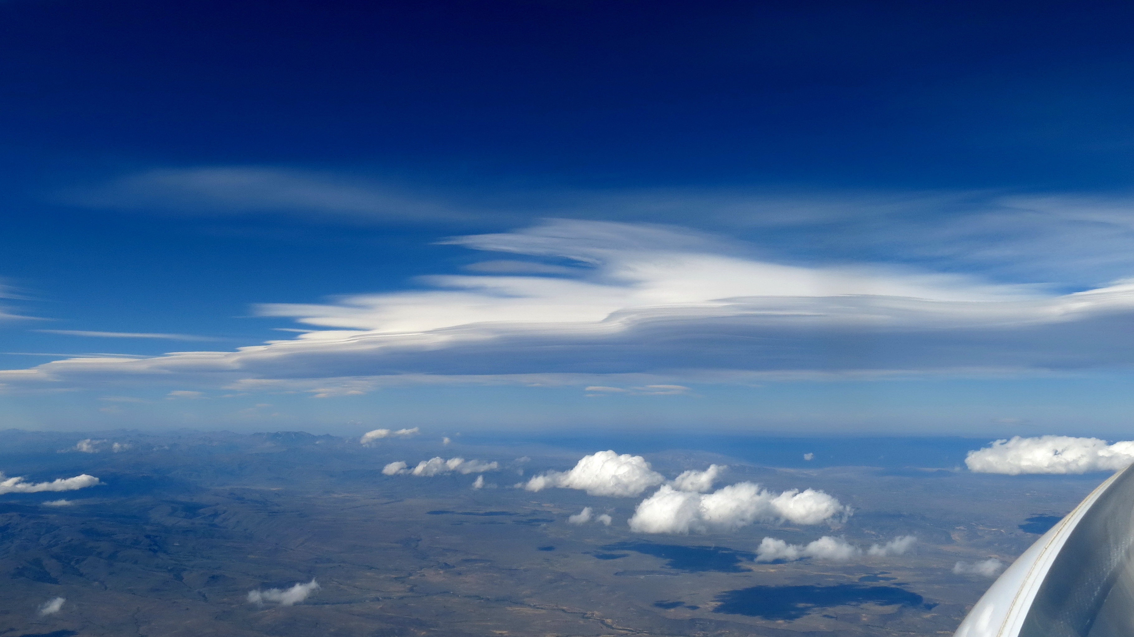
Yes, this is the shape of our lake. Despite the heavy rain, we shall reach home with an L/D approx. 10, as expected.

January 2nd, at the Northern turning point, in the hydraulic jump of Catan Lil at 8,000 m in blue sky, near Vne with 3.5 m/s vario and 5.9 m/s netto.
The most beautiful hydraulic jump of the season was once again the one of Catan Lil, to the point that one of my friends, airline pilot at LAN, called me in the evening to discuss this phenomenon because the had passed few thousand feet above me when I was at FL280 (thanks TCAS!) under this cloud. I retrieved the satellite images, the comments are in the captions of photos
January 6th, point BIVIK, 250 km South of Bariloche at 7,200 m looking North. We perfectly see the strato-cumulus rolls of the resonant gravity waves system, together with the associated lenticulars a little further North, and, at the upper level, the cirrus whose “fringed” leading edge is the perfect testimony of a hydraulic jump that develops over 500 km. The Vz of the sinusoidal gravity waves are higher than those of the hydraulic jumps, but it is necessary to surf from one wave to the other and therefore slow down from time to time to climb. On the other hand, the front of the hydraulic jump, although very fringed, makes it possible to follow an average trajectory at a relatively constant altitude, the final result being, in my opinion, in favor of following the front of the jump. But this is purely subjective. I have also often observed that the wind horizontal speed component in the front of the jump is significantly lower than that of the average airmass, which makes it possible to reach a higher cruising speed. We could observe that the front of the jump is apparently disconnected from the rebound gravity wave systems, and by following (in the blue) the leading edge of the pseudo lenticular, I often found myself above the crest of the Cordillera, sometimes even very much inside the mountains (Andy Aveling shall recall such an amazing situation in January 2011).
January 6th at 20:12Z, 140 km North of Bariloche looking North. Zapala is 110 km ahead in the dark, in the direction of the fuselage, the mountain visible at left in the shadow of the “monster” is Catan Lil. There are also beautiful conventional gravity wave rotors generated by the valleys visible beneath, only a few hundred meters depth, and lenticular clouds in the background. The pseudo lenticular of the hydraulic jump looks like a conventional lenticular because it has a well defined trailing edge, and in fact both systems are combined in this area. Above it, the true pseudo lenticular can be seen, typical of the hydraulic jump, with its highly fringed leading edge, and not definite trailing edge, as evidenced by the shadow that is carried up to the horizon. We are at 5,100 m, this cloud is 120 km in front of us, we will turn back home after the usual photos at more than 8.000 m.
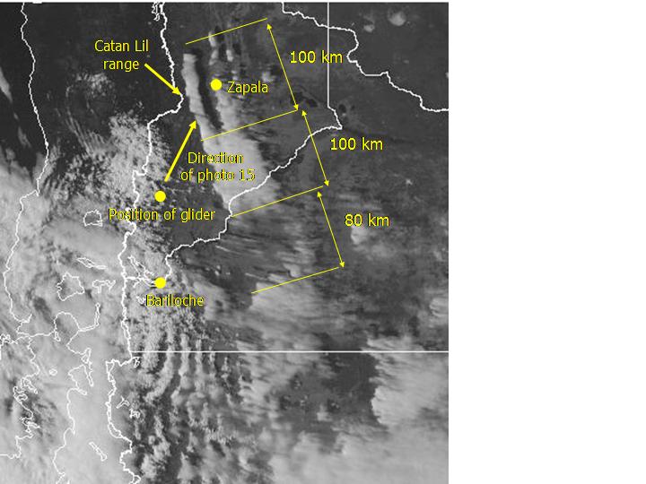

Satellite photo of the same area at 20:45Z, 30 minutes after taking photo above. We can very clearly see the resonant waves we had used South of Bariloche, the small rotors of isolated gravity waves above the pampa, the lenticular cloud visible on the photo, repeated three times. This demonstrate that both systems are combined, their length is about 100 km. That combination extends for another 100 km, but the lenticular clouds are immersed inside the pseudo lenticular visible in the photo, having a width of about sixty kilometers, and more to the South, the residual fringes show the existence of the nascent hydraulic jump whose exploitation is probably not simple. The structure continues several hundred kilometers to the South. This is a pre-frontal situation, with the cold front visible on the left. The crest line of the mountains is materialized on the satellite image by the border line with Chile.
Satellite photo of the same area at 23:08Z, the last in the visible spectrum. The initial structure of the most Northerly 200 km has not changed by a millimeter, confirming the presence of the orographic gravity wave, mixed together with the hydraulic jump. While the Southern part has been reinforced to form a perfect pseudo lenticular whose trailing edge extends until the Atlantic Ocean, the leading edge is exactly that of the cirrus of the previous photos at an altitude of about 10,000 m. Obviously, this phenomenon has nothing to do with the orography. It can be observed that the resonant gravity wave trains are now well structured and the 1,500 km O/R could have been flown above 250 km/h, if we could have more than two hours of remaining light.
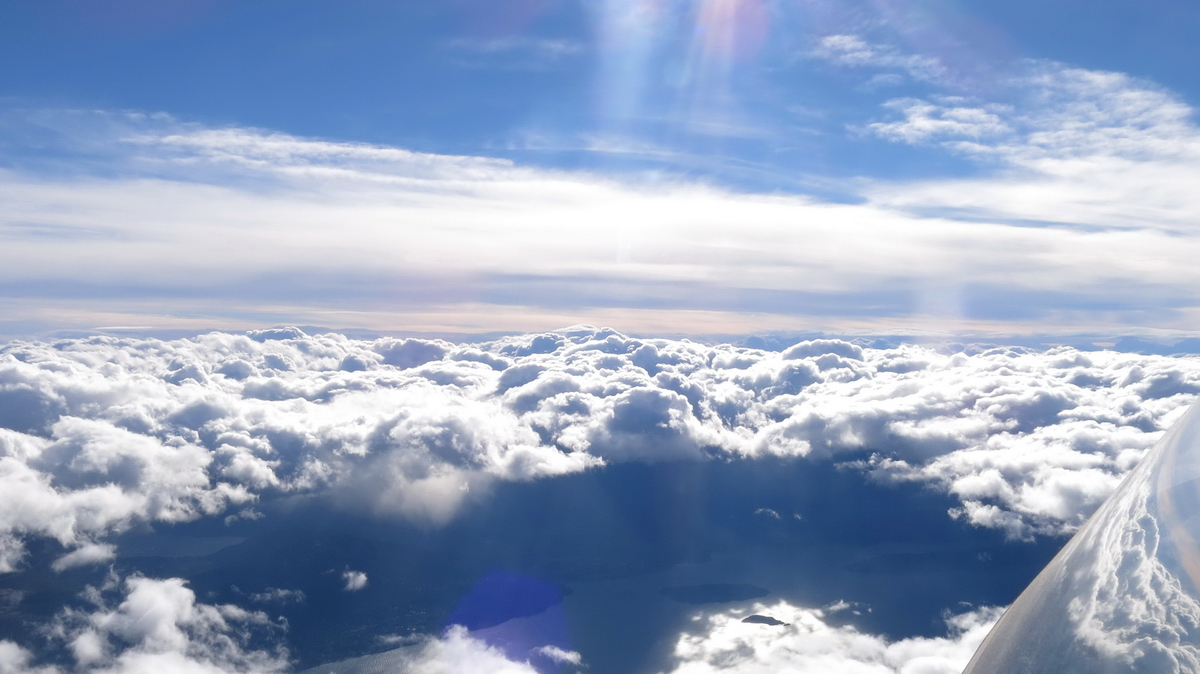
A frequent situation: the front is entering Bariloche area via the lake, with a solid cover cloud having a top around 5.000 m. It is necessary to climb above 6.000m. The ATC always agree, because this is much higher than the landing and take off procedures, then ask the friends on the ground whether they see some sun somewhere, and check the presence of a hole, such as the one you can see here. We could always return back home, contrary to previous years.
.